Simon and Garfunkel's song "America" tells the story of "young lovers hitchhiking their way across the United States, in search of 'America,' in both a literal and figurative sense," as the Wikipedia entry about the song so aptly puts it. They travel from Michigan through Pennsylvania and New Jersey, presumably en route to New York City, that mecca of fashion and culture and commerce. As much as I love the song, I've always felt that the young lovers were heading in the wrong direction. The road to America lies west, not east. Or at least it does for me.
My 40th birthday happened to coincide with another invitation to judge
at a model horse show in Colorado. Five years had passed since last I
had visited that state, and my need to see mountains and wide-open skies
had been steadily growing ever since, so I jumped at the chance. Much
to my delight, my sister and her boyfriend decided to make the trip as
well, and we all met up in Denver for a mini adventure before the show.
For a while now, I've been doing my unsubtle best to convince them that
they, too, should move to Colorado (as I hope to do eventually (although probably only after winning the lottery at this rate)). So I created an itinerary that I hoped would
maximize dramatic scenery and fun. I had thought some of going up to
Rocky Mountain National Park and staying somewhere in the mountains, but
as it was only April, Trail Ridge Road through RMNP was still buried in
snow, and the forecast was a tad dicey elsewhere in that area. Rather than risk icy conditions, we
headed south toward Colorado Springs to do the touristy thing where warmer weather was more likely.
On the road south
Our first stop was an overlook along the highway with a spectacular view of Pike's Peak and its neighbors.
Snow cap on Pike's Peak
Panorama of the Rampart Range
Our ultimate destination that afternoon was Garden of the Gods. My
sister and I had seen it briefly on our trip in 2010, but this time
around, we were determined to really explore the area. It was a warm, extremely windy day which felt amazing to me after a long, ugly winter in Chicago. We spent most of our time wandering through the central Cathedral Valley of the park taking pictures and watching a couple of climbers scale the hogbacks. About 250 million years ago, these massive tilted sedimentary rocks were part of the floor of an inland sea that lapped up to the front range of the Ancestral Rockies. Over the millennia, the Ancestral Rockies eroded away, and the climate dried, turning the area into a desert that stretched across much of the southwest. Around 65 million years ago, the uplift that formed the present day Rocky Mountains tilted these slabs on end, creating this amazing landscape.
Kissing Camels
White rocks
Orange rocks
Plaque commemorating gift of the park to Colorado Springs
The land on which Garden of the Gods sits was willed to the city of Colorado Springs in 1909 upon the death of its owner, Charles Perkins, with the stipulation that it be turned into a free public park. More than 100 years later, the park draws sight-seers, hikers, climbers, nature lovers, international tourists, and people utterly bored to death with city-scapes like me.
Tall rocks
Pointy rocks
Still more rocks
The view from the back side of the largest fins
One thing that always fascinates me about Colorado is the wealth of outdoor sculpture, often whimsical, that turns up in all sorts of out of the way places. These delightful life size metal saguaro cacti greet visitors to the Garden of the Gods trading post.
The security officer in the trading post was kind of intense
The trading post sells the usual mix of generic touristy, outdoorsy kitsch (which is fun, don't get me wrong), but I was most interested in the exquisite Navajo rugs and sandpaintings and the Puebloan pottery.
A unique and lovely sandpainting on a light shade!
Navajo rugs
Mind-blowing, intricately patterned pottery from Acoma pueblo
We made a last circuit of the park just before dusk, stopping at the geological wonder that is Balanced Rock. Millennia of erosion from wind and rain have worn away the rock around it, leaving it seemingly precariously balanced over the road.
Scale is hard to judge from photos, but this rock is a massive 35 feet high
Our hotel was just a few minutes away in Manitou Springs in the shadow of Pike's Peak. We drove through town and up the pass beyond a ways, but evening was coming on, and we were hungry, so we turned back. (Alas, none of my pictures from that drive turned out well enough to share.) We poked around the various interesting shops and restaurants in Manitou and ultimately opted to eat at The Loop, a Mexican restaurant. This proved to be an inspired choice because the food was absolutely amazing. I'm not normally a foodie, but their quesadillas were so good, I had to be that person and take a picture of my plate.
Having stuffed ourselves mightily, and having brought home leftovers to boot, we returned to our hotel and promptly all fell into sleepy, contented food comas. Our plans for the next day depended on the weather, but would involve mountains one way or the other. Westward, ho, to look for more America!
The last day of my week-long trip through Colorado took me across the northwestern part of the state from Grand Junction to Denver along I-70, considered to be one of the country's top engineering marvels by the US Department of Transportation. And given the often challenging terrain it traverses, that's no surprise. The road follows the Colorado River valley much of the way before climbing up into the Rockies and over the Continental Divide.
Mt. Garfield dominates the skyline as you drive east out of Grand Junction.
The road then winds north, following the meandering Colorado River towards its headwaters high in the Rockies.
The Colorado River valley is broad and green, bordered by rolling hills to the north and south. The dichotomy between the terrain from one side of the road to the other is fascinating.
To the north/west, the hills are more arid.
To the south/east, the vegetation is much more lush.
Gradually, the hills close in on either side as you approach the spectacular Glenwood Canyon stretch of I-70. Completed only in 1992, it was the last part of the transcontinental interstate system to be opened to traffic. The narrow canyon was first traversed by the Denver and Rio Grande Western Railroad in the late 1800s to provide a corridor to parts west without having to take long detours through passes in either Wyoming or New Mexico.
The Union Pacific still operates on the tracks on the south
bank of the river.
After some political wrangling, the Glenwood Canyon route was secured for traffic as well, and the engineers who built it did their best to preserve the natural beauty of the canyon.
To do so, and because to the narrowness of the canyon itself, several special measures were taken
such as tunnels...
and elevated roadways.
The walls of the canyon rise well over 1000 feet above the river.
My pictures can't really convey how awe inspiring Glenwood Canyon is, so check out this fantastic dash cam video by Cosmo Photography of a drive through the canyon.
One of the best features of the canyon, besides its incredible beauty of course, is a pedestrian/bike trail that runs beside the river for 16 miles between the towns of Dotsero and Glenwood Springs (incidentally, the final resting place of Doc Holliday). I am looking forward to the day when I can ride that trail and pay my respects to one of the most colorful characters of the Old West.
At Dotsero, the Colorado River makes a hairpin bend to the north, but the road continues east following a tributary, the Eagle River. The land flattens out into a broader valley, but the elevation continues to rise.
Before too long, snow capped peaks appeared on the horizon.
We passed through several ski resorts such as Edwards, Eagle, and Vail, and we were impressed by the amount of snow still on the ground even in late May. I was also interested to see more pedestrian/bike trails that followed the highway between the towns.
Near Vail Pass (elevation 10,662 feet)
By driving through the Eisenhower Tunnel, we crossed over Loveland Pass as well as the Continental Divide at 11,992 feet, the highest point in our trip through Colorado.
We continued east, but made a few detours along the way in several mining towns.
The Silver Plume museum
An ore cart
We stopped at an overlook above the Georgetown Loop and were accosted by this extremely friendly chipmunk.
The Georgetown Loop is a stretch of narrow gauge track between the towns of Georgetown and Silver Plume. The towns themselves are only about 2 miles apart, but the tracks traverse a big loop of about 4.5 miles in order to make the climb of 600 feet in elevation to Silver Plume.
The bottom of the loop, a spectacular trestle bridge
Finally, at the Georgetown welcome center, we found a big horn sheep. Not quite what we had in mind when we traveled through Big Horn Sheep Canyon earlier in the week, but beggars can't be choosers.
And a mountain lion for good measure.
We checked out a few antique stores in town and the local trading post to look at Navajo jewelry before getting back in the car. This part of Colorado was part rich in gold and silver, and a number of mining structures still exist.
Past Georgetown, we turned off I-70 onto US Highway 6 which follows Clear Creek, a tributary of the South Platte River.While not as deep as Glenwood Canyon, it was equally picturesque.
For perspective, that rock was bigger than our van.
As with other places in Colorado, the old railroad roadbed along Clear Creek has been converted into a trail for walking, biking, etc.
The road took us past the Coors Brewery, by which Clear Creek runs, so they're really not kidding about mountain fresh water. (I can't say for sure of course; I never acquired a taste for beer. But they do have an amazing location.)
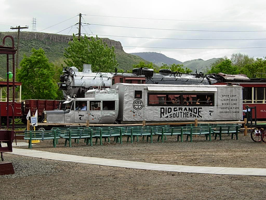
To close out the day, we stopped at the Colorado Railroad Museum in Golden. Originally founded in 1958 in Alamosa to preserve Colorado's history (which was largely driven by the railroads), the collection includes rolling stock such as engines, boxcars, cabooses, etc; old railway records; and various equipment. The museum also boasts an excellent, interactive HO-scale layout as well as an impressive bookshop.
Galloping Goose #7
One of many neat items preserved by the museum, a sign from the long-gone
Lizard Head Pass depot/section house.
Absolute heaven for an avid railfan like my dad.
Golden really is a neat town. I can't wait to go back!
One last bit of CO public art.
And a hazy farewell to the Rockies. Until next time!
I was very sad to reach the end of my extraordinary, life-altering week-long trip. I wanted to turn around and do it all over again---see more places, climb more mountains, explore more out of the way corners of the southwest. As a friend of mine put it, you end up leaving a piece of your heart there. But the good thing is that you carry away a piece of the landscape with you in your memory and soul. No matter how long you're away, it's there, waiting to be looked at and remembered and yearned for. The more I go back, the more sure I am that Colorado and the southwest is where I belong.
The trip also made me finally realize not only where I wanted to be but what I wanted to be. I'm not there yet in either aspect, but I hope to be soon. As John Muir once wrote, "the mountains are calling and I must go."