Showing posts with label georgetown loop. Show all posts

Monday, March 4, 2019

"Going to the mountains is going home"

We have at long last made it to March which is usually the last gasp of winter here in Chicago. Not so today. We're starting the week with a couple of days of freakish, sub-zero cold. At least by the weekend, temperatures are supposed to rise to a more normal range in the '30s and '40s. But March is a tease---we'll get hints of spring here and there, but then we'll probably have more snow, too, just as soon as I've put away my Yak-trax. It won't really be properly warm and spring-like until late April or early May, so it's about this contrary time of year that cabin fever starts creeping up on me. I feel an increasingly desperate need to go somewhere not only sunny but also warm and much less populated and with prettier scenery and... basically, I feel the need to go out west again. The wanderlust gets stronger every day.

Not surprisingly, I felt that way last April on the final day of our trip to Colorado. We all had flights home that afternoon, but as John Muir said, the mountains were calling, and we had to go. Since we needed to stay in the vicinity of Denver, the easiest way to experience mountains was to drive out I-70 a ways. Happily, this is also a spectacularly scenic route; I-70 between Denver and Grand Junction in western Colorado is probably the most beautiful stretch of interstate in the whole country. So we rolled out early and set off west from Aurora.


Both my sister and I had made the drive east from Grand Junction to Denver in 2010, but we'd never had the experience of going the other direction. And my sister's boyfriend had never seen the mountains up close, so we all felt we were in for a treat.


The trip across town into the foothills beyond Golden didn't take much more than 30 minutes, and after a few miles of climbing, we reached our first clear view of snow-capped peaks framed perfectly by the Genesee Trail Road bridge as we crested a rise.


Our goal for the morning was to reach the Continental Divide via Loveland Pass and the Eisenhower Tunnel, a road that would take us right through the snowy peaks in front of us.


We still had some 40 miles to traverse however...


...through the former mining town of Idaho Springs...


...and winding through incredible rock formations.


The temperature was quite pleasant at lower elevations...


...but winter still had a firm grip the higher we climbed.


As we drew closer to the Continental Divide, the views were dominated by Mt. Sniktau to the south...


...and Mt. Bethel to the north.


The snow on the mountains under bright sun was sublime.


Up, up, up we went, nearly to the tree line.


And into the tunnel! As we drove though, we crossed the Continental Divide and reached an elevation of 11,158 feet, the highest point on the Interstate Highway System (and nearly 6,000 feet higher than where we started the day).


When we popped out on the other side, the road was still wet from freshly fallen snow that was melting in the morning sun.


I would have loved to go out as far as Glenwood Canyon, but having flights to catch meant we needed to turn around at the next exit and head back.


We enjoyed views of Buffalo Mountain as we descended into Silverthorne.


Buffalo Mountain (below, left) and Red Peak (below, right) loom over the small town of Silverthorne which interestingly was named for a person rather than the precious metal. Though some mining took place in the area, the town mostly owes its existence to the nearby Dillon reservoir and to skiers.


We stayed only long enough to put a little gas in the car and then headed back east.


The scenery was of course incredible in both directions.


The tunnel on the western side of the pass is pretty much even with the tree line...


...and is slightly below it when you emerge on the other side.


Just outside of Georgetown, we stopped at an overlook to see the Georgetown Loop, a narrow gauge railroad trestle that is part of a line between Georgetown and Silver Plume. They are only two miles apart, but Silver Plume sits some 600 feet higher than Georgetown, hence the long sweeping curves and loops of track to connect the two towns at a reasonable grade.


Looking back up the valley toward Silver Plume

Both the sign and the stickers were interesting.
One of these days, I hope to have the money and the leisure to drive I-70 through Colorado and stop to admire all of the pretty vistas...


...and the various quirky points of interest along the way.


As much as I love the mountains and high passes, I find the rolling green foothills of the Rockies compelling as well.


There's something about the contrast of the landscape against that wide-open sky that makes my heart sing. I don't know how anyone can visit this place and not fall irrevocably in love.


My ties to Colorado and the mountains are tenuous at best---my great-grandparents and their parents and siblings ran sheep in a tiny town nestled in a valley behind the Front Range. Distant cousins of mine still live there in the house my great-great-grandparents built, and more than a few of my ancestors died and were buried in Colorado. So I do have roots there after a fashion. The line in John Denver's song Rocky Mountain High about coming home to a place you've never been before has always a struck a chord with me (no pun intended) for this reason. 

This last year since taking the trip to Colorado has largely been one of upheaval and unhappiness for me, and I find myself more than ever adrift and longing to finally settle somewhere I love for good. Chicago has never been home to me despite nearly twenty years living here, and I'm tired of not having a place to really call my own. I don't know if I can afford to move to Colorado anymore---New Mexico is looking like a smarter option in terms of cost of living---but wherever I end up, there must be mountains. Because John Muir was right. Going to the mountains is going home.
Wilderness is not a luxury but a necessity of the human spirit.
Read more at: https://www.brainyquote.com/quotes/edward_abbey_383238
Wilderness is not a luxury but a necessity of the human spirit.
Read more at: https://www.brainyquote.com/quotes/edward_abbey_383238
Wilderness is not a luxury but a necessity of the human spirit.
Read more at: https://www.brainyquote.com/quotes/edward_abbey_383238

Thursday, April 18, 2013

Colorado River Country

The last day of my week-long trip through Colorado took me across the northwestern part of the state from Grand Junction to Denver along I-70, considered to be one of the country's top engineering marvels by the US Department of Transportation. And given the often challenging terrain it traverses, that's no surprise. The road follows the Colorado River valley much of the way before climbing up into the Rockies and over the Continental Divide.

Mt. Garfield dominates the skyline as you drive east out of Grand Junction.

The road then winds north, following the meandering Colorado River towards its headwaters high in the Rockies. 


The Colorado River valley is broad and green, bordered by rolling hills to the north and south. The dichotomy between the terrain from one side of the road to the other is fascinating.

To the north/west, the hills are more arid.
To the south/east, the vegetation is much more lush.
Gradually, the hills close in on either side as you approach the spectacular Glenwood Canyon stretch of I-70. Completed only in 1992, it was the last part of the transcontinental interstate system to be opened to traffic. The narrow canyon was first traversed by the Denver and Rio Grande Western Railroad in the late 1800s to provide a corridor to parts west without having to take long detours through passes in either Wyoming or New Mexico.

The Union Pacific still operates on the tracks on the south
bank of the river.
After some political wrangling, the Glenwood Canyon route was secured for traffic as well, and the engineers who built it did their best to preserve the natural beauty of the canyon. 

To do so, and because to the narrowness of the canyon itself, several special measures were taken
such as tunnels...

and elevated roadways.

The walls of the canyon rise well over 1000 feet above the river.
My pictures can't really convey how awe inspiring Glenwood Canyon is, so check out this fantastic dash cam video by Cosmo Photography of a drive through the canyon.


One of the best features of the canyon, besides its incredible beauty of course, is a pedestrian/bike trail that runs beside the river for 16 miles between the towns of Dotsero and Glenwood Springs (incidentally, the final resting place of Doc Holliday). I am looking forward to the day when I can ride that trail and pay my respects to one of the most colorful characters of the Old West.

At Dotsero, the Colorado River makes a hairpin bend to the north, but the road continues east following a tributary, the Eagle River. The land flattens out into a broader valley, but the elevation continues to rise.


Before too long, snow capped peaks appeared on the horizon.


We passed through several ski resorts such as Edwards, Eagle, and Vail, and we were impressed by the amount of snow still on the ground even in late May. I was also interested to see more  pedestrian/bike trails that followed the highway between the towns.

Near Vail Pass (elevation 10,662 feet)

By driving through the Eisenhower Tunnel, we crossed over Loveland Pass as well as the Continental Divide at 11,992 feet, the highest point in our trip through Colorado.


We continued east, but made a few detours along the way in several mining towns.

The Silver Plume museum
An ore cart
We stopped at an overlook above the Georgetown Loop and were accosted by this extremely friendly chipmunk.


The Georgetown Loop is a stretch of narrow gauge track between the towns of Georgetown and Silver Plume. The towns themselves are only about 2 miles apart, but the tracks traverse a big loop of about 4.5 miles in order to make the climb of 600 feet in elevation to Silver Plume.

The bottom of the loop, a spectacular trestle bridge
Finally, at the Georgetown welcome center, we found a big horn sheep. Not quite what we had in mind when we traveled through Big Horn Sheep Canyon earlier in the week, but beggars can't be choosers.

And a mountain lion for good measure.

We checked out a few antique stores in town and the local trading post to look at Navajo jewelry before getting back in the car. This part of Colorado was part rich in gold and silver, and a number of mining structures still exist.


Past Georgetown, we turned off I-70 onto US Highway 6 which follows Clear Creek, a tributary of the South Platte River.While not as deep as Glenwood Canyon, it was equally picturesque.

For perspective, that rock was bigger than our van.
As with other places in Colorado, the old railroad roadbed along Clear Creek has been converted into a trail for walking, biking, etc.


The road took us past the Coors Brewery, by which Clear Creek runs, so they're really not kidding about mountain fresh water. (I can't say for sure of course; I never acquired a taste for beer. But they do have an amazing location.)


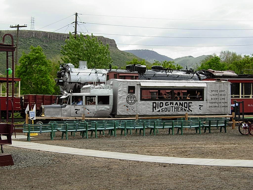
To close out the day, we stopped at the Colorado Railroad Museum in Golden. Originally founded in 1958 in Alamosa to preserve Colorado's history (which was largely driven by the railroads), the collection includes rolling stock such as engines, boxcars, cabooses, etc; old railway records; and various equipment. The museum also boasts an excellent, interactive HO-scale layout as well as an impressive bookshop.
Galloping Goose #7

One of many neat items preserved by the museum, a sign from the long-gone
Lizard Head Pass depot/section house.
Absolute heaven for an avid railfan like my dad.
Golden really is a neat town. I can't wait to go back!
One last bit of CO public art.
And a hazy farewell to the Rockies. Until next time!
I was very sad to reach the end of my extraordinary, life-altering week-long trip. I wanted to turn around and do it all over again---see more places, climb more mountains, explore more out of the way corners of the southwest. As a friend of mine put it, you end up leaving a piece of your heart there. But the good thing is that you carry away a piece of the landscape with you in your memory and soul. No matter how long you're away, it's there, waiting to be looked at and remembered and yearned for. The more I go back, the more sure I am that Colorado and the southwest is where I belong.

The trip also made me finally realize not only where I wanted to be but what I wanted to be. I'm not there yet in either aspect, but I hope to be soon. As John Muir once wrote, "the mountains are calling and I must go."